ISOLATION OF NON-GRAVITATIONAL SIGNAL
BY COMBINATIONS OF DUAL-SATELLITE CROSSOVERS
Jaroslav Klokočník (2), Carl A. Wagner (1), Jan Kostelecký (3),
Marcela Jandová(2)
(1) NOAA, 1305 East-West Highway, Silver Spring, MD-20910, USA.
(2) Astronom. Inst. Czech Acad. Sci., CZ-251 65 Ondřejov Observatory
(3) Faculty of Civil Eng., CTU Prague, CZ-160 00 Prague 6, Thákurova 7 and Research Institute of Geodesy Topography and Cartography, CZ - 250 66 Zdiby.
![]()
The Dual-Satellite altimetry Crossover (DSC) residuals among Geosat, T/P (TOPEX/Poseidon), and ERS 1 and their combinations are used to detect geographically fully correlated part of the radial orbit error. This component is hidden to ordinary tests with full altimetry data or to the single-satellite crossovers (SSC). We demonstrate the likely presence of non-geopotential errors by looking at certain combinations of the crossover data which theoretically (or statistically) remove (or cover) the geopotential effects. A part of non-geopotential effects can be separated and reduced from the data. The goal is to reduce all such effects before using DSC to refine global Earth gravity field models. Alternatively, we should be able to construct long-term "oceanographic" series of crossover data interconnecting two (or more) altimetry missions.
Accepted for presentation at the Symposium "G07 Satellite Altimetry Applications for Geodesy", AGU 1999 Fall Meeting, SF, 13-17 December.
Figs. 1, 2, 5, 7, 8 Figs. 3, 4, 6, 9
Combinations of Dual Altimetry Crossovers
There is one type (AD) of single-satellite crossovers (SSC) between the ascending and descending track of the given orbit, just four types (AD, DA, AA, and DD) of dual-satellite crossovers (DSC) between the relevant tracks of a pair of satellite orbits, and just twelve their combinations (AA+AD, AA-AD, AA+DA, AA-DA, DD+DA, DD-DA, DD+AD, DD-AD, AD+DA, AD-DA, DD+AA, and DD-AA
), taken in pairs. Each quantity has different sensitivity to the gravity field parameters and in turn, also different gravity induced error (Klokočník and Wagner, 1999; Klokočník et al, 1995, 1999a, Wagner et al, 1997b).
Let us consider now the following 4 from all 12 DSC combinations:
(1) ![]()
(2) ![]()
(3) ![]()
(4) ![]()
According to Rosborough (1986),![]() is the geographically correlated part of the radial component or error (also called 'mean') and
is the geographically correlated part of the radial component or error (also called 'mean') and ![]() is the variable part (also called geographically anti-correlated). Both are gravity-induced; the non-gravitational effects are not described by this theory; thus, the right hand sides of eqs. (1) to (4) are representing only the gravity field induced effects. Not so necessarily the left hand sides, derived from observations.
is the variable part (also called geographically anti-correlated). Both are gravity-induced; the non-gravitational effects are not described by this theory; thus, the right hand sides of eqs. (1) to (4) are representing only the gravity field induced effects. Not so necessarily the left hand sides, derived from observations.
In the case of full altimetry data ![]() , there is no way to separate the correlated and anticorrelated parts. Also, in the case of one satellite only, the single-satellite crossovers (SSC) are known to have no correlated part
, there is no way to separate the correlated and anticorrelated parts. Also, in the case of one satellite only, the single-satellite crossovers (SSC) are known to have no correlated part![]() . Only the DSC contain the geographically correlated part (a difference for the satellite pai
. Only the DSC contain the geographically correlated part (a difference for the satellite pai
Data
We use NOAA GDR files for Geosat, NASA/JPL GDRs for T/P and ESA ODRs for ERS 1. The orbit basis for the altimetric heights for the Geosat and T/P files is the Jgm 3 geopotential (Tapley et al, 1996). The basis for ERS 1 heights is also Jgm 3 for an early release (1996) but the model Dgm E04 DUT (Scharroo and Visser, 1998) was used for Pathfinder data since 1997. The crossovers were computed at NOAA, Silver Spring, from algorithms by one of the authors (CW) for Pathfinder data, and Russ Agreen for data from the other sources. For check purposes, we also used DSC of Geosat&T/P Jgm 3-based, reduced in GFZ, Potsdam (M. Rentsch et al, priv. commun, 1998).
The original altimeter heights for all three missions were first reduced to sea surface heights using the reference orbits and a standard ellipsoid and geoid for all three missions after correction for path delays and biases from a number of media sources (Table 2). A change in the sea state bias for T/P occured (J. Kuhn, priv. commun.) between an earlier (1996) release used by NOAA and one employed in 1997 (Pathfinder).
We make use only of long-term averaged (over 1-3 years) crossover data. Sometimes we must cross over time gap between two altimetry missions (about 8 years between Geosat&Topex or Geosat&GFO, 5 years for Geosat&ERS 1); in such a case we use 'same-month averaging'. The term 'month-to-month' average over x-year gap between years![]() and
and![]() means that we average data from January
means that we average data from January![]() of satellite
of satellite![]() with data from January
with data from January![]() of satellite
of satellite ![]() , Feb
, Feb ![]() of
of ![]() with Feb
with Feb![]() of
of ![]() , etc. In this way we hope to avoid the seasonal fluctuations of both the ocean's surface and media errors as much as possible. Short periodic changes (within a month) are ignored, and longer than a year signals (like El Nino/La Nina) are not completely averaged out.
, etc. In this way we hope to avoid the seasonal fluctuations of both the ocean's surface and media errors as much as possible. Short periodic changes (within a month) are ignored, and longer than a year signals (like El Nino/La Nina) are not completely averaged out.
Three recent Ocean Circulation Models (OCMs), POCM (Parallel Ocean Climate Model, version 4B); Stammer et al, 1996, Carton's OCM (Carton, 1996), and LANL OCM (Los Alamos National Lab., a general circulation model) were tested. We found that the models are not yet enough accurate or discrimining in time or space for our geodetic applications. The goal was to use OCMs as an additional altimetry correction. (This topic is further studied).
Offset
DSC can interconnect two (or more) altimetry missions into one 'geodetic frame' (corresponding to the satellite with more precisely tracked orbit) over many years. It was discovered by Wagner et al (1997a), and numerically computed for Geosat&T/P and ERS1&T/P with the Jgm 2-based DSC residuals (Wagner et al, 1997b) that and how large are the forbidden terms ![]() and
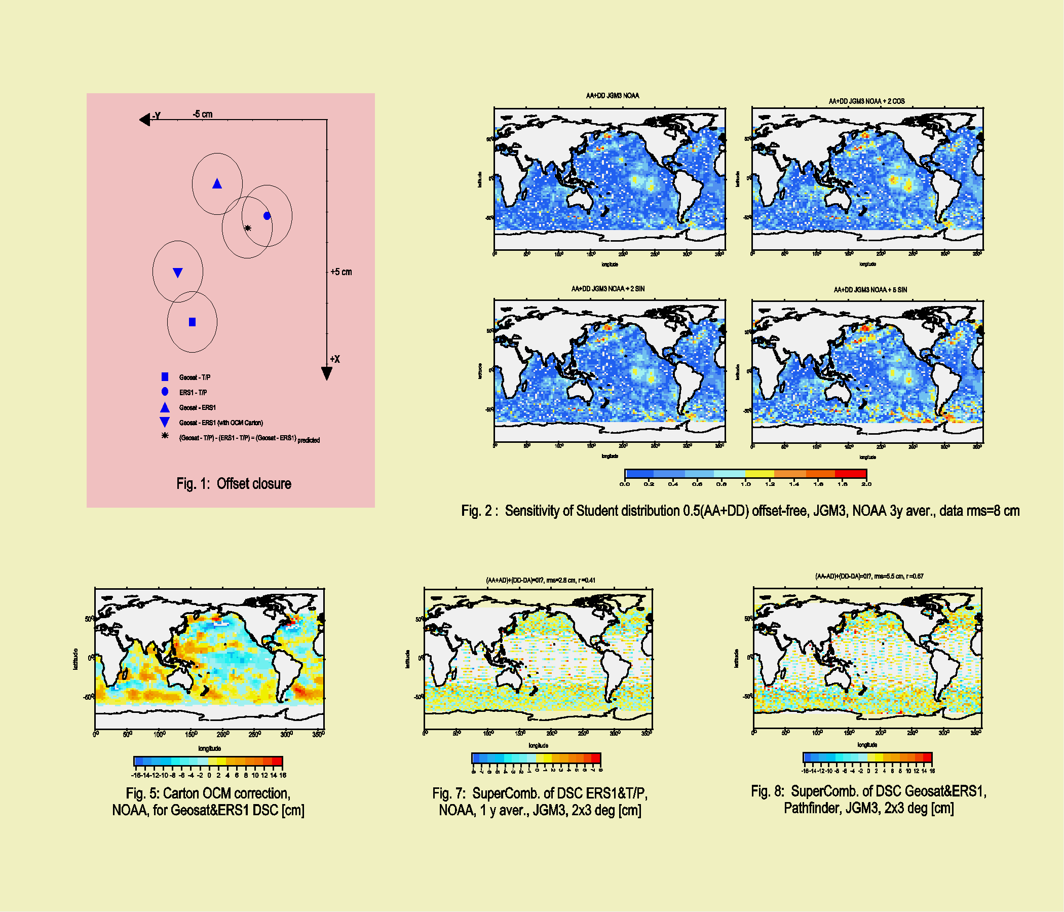
and ![]() representing a relative offset of Geosat (or ERS 1) with respect to T/P (taken as errorless). The new results with the Jgm 3-based orbits are presented here in Table 1, using NOAA, GFZ, and DUT data (for their corrections see Table 2). A 'closure' of all solutions from the solved-for offset from Geosat&T/P, ERS 1&T/P, and Geosat&ERS 1 shows an acceptable consistence (Fig. 1).
representing a relative offset of Geosat (or ERS 1) with respect to T/P (taken as errorless). The new results with the Jgm 3-based orbits are presented here in Table 1, using NOAA, GFZ, and DUT data (for their corrections see Table 2). A 'closure' of all solutions from the solved-for offset from Geosat&T/P, ERS 1&T/P, and Geosat&ERS 1 shows an acceptable consistence (Fig. 1).
The values from Table 1 can directly be used to reduce DSC residuals into one coordinate system (T/P). The correction in sea surface height ![]() has opposite sign as the DSC residuals from (1)-(4), say
has opposite sign as the DSC residuals from (1)-(4), say ![]() . Then (Rapp, 1989; Wagner et al., 1997b):
. Then (Rapp, 1989; Wagner et al., 1997b):
![]()
(
F and l are geodetic latitude and longitude, respectively). However, numerical results from Table 1 should be considered as a first approximation to 'true' values only. The reason is that the offset parameters correlate with the higher degree first order harmonic geopotential coefficients and these coefficients were neglected in our computations (we take the Jgm3-values as errorless). Moreover, the coordinate 'geodetic' offset is only a part of the total
Detection of non-gravitational, non-geodetic signal in
fully correlated part of radial error
DSC residuals and their combinations are based on observations, thus they consist of various gravitational and non-gravitational effects. The gravity induced part is expressed by the Rosborough's components![]() and
and![]() . The non-gravitational parts of the DSC comes from the offset, but also from the remaining errors after the altimetry corrections are applied, including empirical one (like 1 cpr). Unfortunately, there is a contribution from residual errors of tidal models, too. Unknown amount of the DSC signal suffers from an aliasing between the non-gravitational and gravitational signal. Finally, there is also white data noise.
. The non-gravitational parts of the DSC comes from the offset, but also from the remaining errors after the altimetry corrections are applied, including empirical one (like 1 cpr). Unfortunately, there is a contribution from residual errors of tidal models, too. Unknown amount of the DSC signal suffers from an aliasing between the non-gravitational and gravitational signal. Finally, there is also white data noise.
The coordinate geodetic offset between two missions is an example of geographically correlated non-gravitational phenomenon. It does not depend on type of the DSCs (i.e. on sense of satellite's track, and on time). Other non-gravitational effects "slowly variable" can be also considered as analogy to the geographically correlated gravity-induced component of the radial orbit error (e.g., the mean sea surface from OCMs averaging), while the others are an analogy to the variable part (some media corrections).
Numerical examples will be given for the combinations (1) or (3) to detect the correlated part of the radial error. Also the follwoing two 'supercombinations' of the DSC are useful. The difference of (1) and (3) yields
(5) ![]()
which is offset-free, while the sum of all DSC yields (offset-dependent):
(6) ![]()
Anomalous features due to non-gravitational effects in the SSC, DSC and their various combinations should be somehow statistically identified and described. We make use of the Student-t-statistics for this purpose. Basic information follows; for details an
d formulae see (Klokočník et al, 1999b).
Let us consider already offset-free DSC or DSC-combination "![]() " with formal standard deviations
" with formal standard deviations![]() , with the relevant estimate of gravity induced error
, with the relevant estimate of gravity induced error![]() from covariance projection (already calibrated) of that gravity field model which was used to compute orbits of the altimetry satellite and the crossovers themselves. We label the residual values of "
from covariance projection (already calibrated) of that gravity field model which was used to compute orbits of the altimetry satellite and the crossovers themselves. We label the residual values of "![]() " as
" as![]() :
:
(7) ![]()
its error estimate is:
(8) ![]() .
.
The ratio
(9) ![]()
has the character of the Student-t distribution. For plotting figures we make use of the ratio
(10) ![]() ,
,
where the values of the Student distribution t
a ,n for risk a =1% are taken from a table (for this distribution) and the degree of freedom n = min[nC1,nC2,...] from our data files. The ratio rt < 1 means that we accept the zero hypothesis (i.e. that d belongs to set of md ), and rt > 1 means that we reject the zero hypothesis. For n lower than 10, we do not expect that the statistics is conclusive. For higher n, the Student distribution is very similar to normal distribution.
Results
Mean residuals for DSC of Geosat&T/P, and a test of sensitivity of Student statistics.
Figs. 2a-d check the sensitivity of our Student statistics. First, Fig. 2a shows the ratio (10) for the real data (3), the DSC for Geosat& T/P, Jgm 3-based, already free of the geodetic offset. Systematic effects on Fig. 2a are evident. But what we show by this combination is ![]() only, and moreover,
only, and moreover, ![]() (for Geosat) is prevailing. The systematic errors thus must be due to non-gravitational and non-geodetic origin; they are located mainly along the strongest ocean currents - they are probably due to unmodelled ocean currents, and in the tropical Pacific ocean, so this is probably an echo of unmodelled El Nino over the averaging interval of the DSC data (1985Apr1993 to 1986Mar1994).
(for Geosat) is prevailing. The systematic errors thus must be due to non-gravitational and non-geodetic origin; they are located mainly along the strongest ocean currents - they are probably due to unmodelled ocean currents, and in the tropical Pacific ocean, so this is probably an echo of unmodelled El Nino over the averaging interval of the DSC data (1985Apr1993 to 1986Mar1994).
Figs. 2b-d show the same statistics when we added a 'false' signal (zonal) to the above combination, say ![]() or
or ![]() (
(
Offset from semi-independent data: NOAA and GFZ.
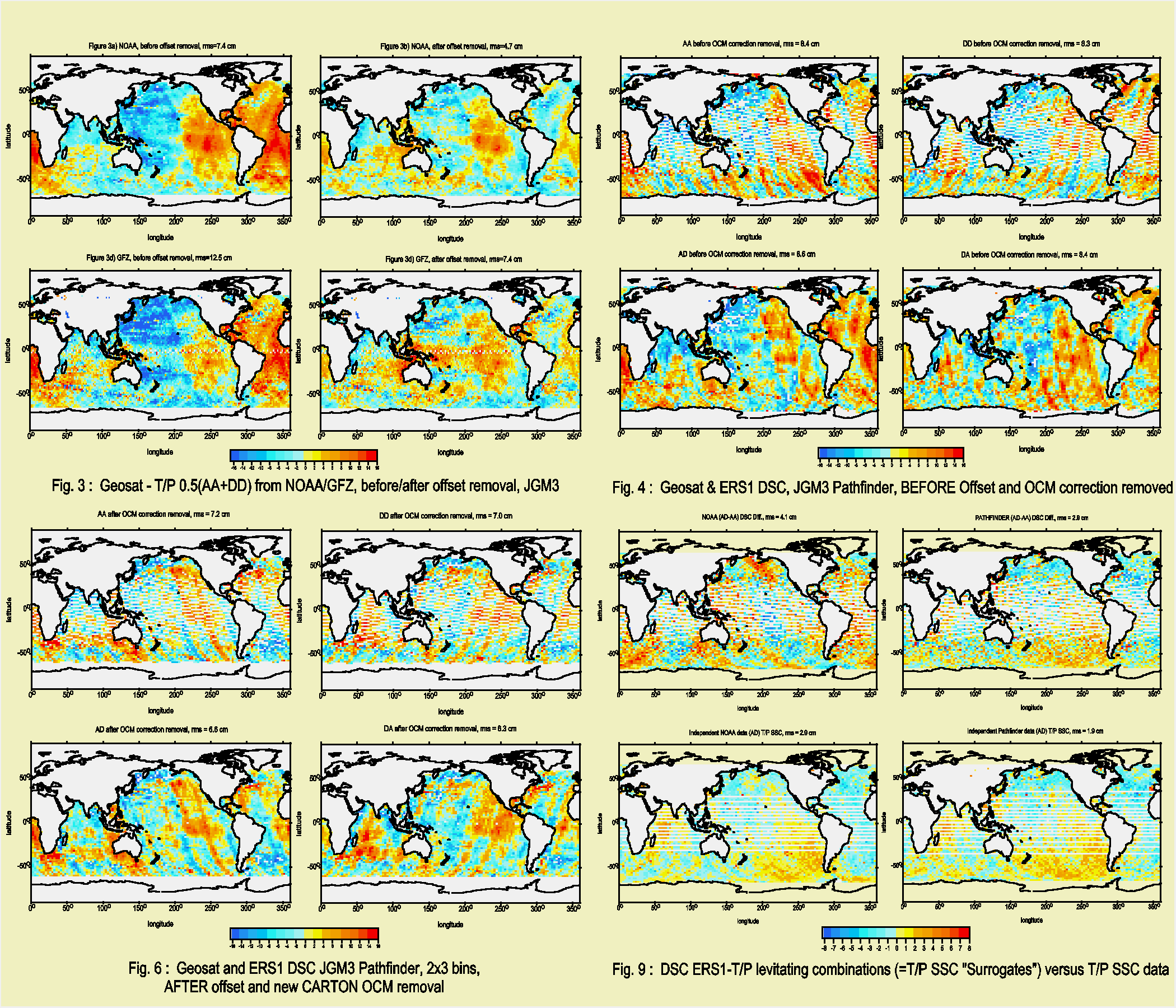
Fig. 3a shows the DSC residuals 0.5(AA+DD) of Geosat&T/P, NOAA data (Jgm 3-based as above) before the relative coordinate offset removal. Fig. 3b shows the same after the offset removal (by using the values from Table 1). Fig. 3c shows that combination of Geosat&T/P, but with the German GFZ data (Jgm 3) before the offset removal, Fig. 3d after it. NOAA and GFZ DSC combinations are semi-independent. The offset is similar in both cases (Table 1); theoretically it should be identical (but the altimetry corrections are not exactly the same, and also, procedures for generation of the crossovers differ).
Offset when OCM is accounted for.
Figs. 4a-d show DSC of Geosat&ERS 1 before the offset removal, Fig. 5 is an example of the Carton OCM correction for this pair, and Figs. 6a-d show DSC of Geosat&ERS 1 after the offset removal, when also the OCMs as an additional correction was applied. We do not see any significant reduction of rms of the DSC residuals after the inversion, and although the offset values have changed, it is not a dramatic change.
Other comments to the mean part of the radial orbit error.
We also tested the combinations 0.5(AA+DD) for Geosat&ERS 1 and ERS 1&T/P, and 0.5(DA +AD) for ERS 1&T/P, all with and without the offset removed. The Student statistics was again applied (not shown here). The result for Geosat&ERS 1 is similar to that of Geosat&T/P, while for ERS 1&T/P, there is no such remaining signal along the main currents or due probably to El Nino. The interpreation is simple: while there are up to 8 or 5 year gaps between Geosat or ERS 1 and T/P, respectively, the crossovers of ERS 1&T/P are computed from (nearly) 'simultaneous' altimeter measurements.
Scharro and Visser (1998) observed systematic effects of the fully correlated part for ERS 1&T/P (their Plate 6b) and explained them as caused probably by the reference frame offset or errors in a few zonal gravity coefficients (not adjusted in their gravity model). In the light of our previous examples, we interpret their systematic residuals (not only in Jgm 3 but remaining also in their tailored model Dgm E04, although to a lesser extent) as due to the relative coordinate 'geodetic' offset dominantly.
Check with 'supercombinations', eq. (5).
The difference of eqs. (1) and (3) yields theoreticaly zero, eq. (5). We display this 'supercombination' at various latitudes and longitudes for ERS 1&T/P, NOAA data on Fig. 7, and Fig. 8 for Geosat&ERS 1, Pathfinder data, both with 1 y averaging, both Jgm 3-based, 2x3 deg bins in latitude and longitude. Indeed, we can see just a noise of the crossover residuals, no systematic signal. This result indicates that the way how the DSC are generated and reduced, and how the covariance errors are projected into the relevant DSC combinations is correct.
Variable part of the radial error, levitating combinations of DSC.
Two of the twelve DSC-combinations differ remarkably from the others (Klokočník and Wagner, 1999); these are:
(11) ![]()
But ![]() is nothing else than the SSC residuum of that satellite itself. If the second satellite is T/P (higher orbit), then
is nothing else than the SSC residuum of that satellite itself. If the second satellite is T/P (higher orbit), then ![]()
We can compute SSC of T/P twice: firstly, directly from "observations", and secondly, from the DSC-combinations in (11), 'surrogating' the SSC. Thus, we can test non-geopotential residual errors in the higher orbit by this way! [Notice that (11) is a difference, so it is offset-free by definiton].
Figs. 9a-d show one such application for ERS 1&T/P. The levitating surrogating combinations (AD-AA) are shown on Figs. 9a using the NOAA data and Jgm 3, and on Fig. 9b with the Pathfinder data, using Jgm 3 for T/P, but Dgm E04 for ERS 1 (see Scharroo and Visser, 1998). The 'original' SSCs (AD) of T/P (Jgm 3-based or to Jgm 3 transformed) are then on Figs. 9c and d.
The two direct sources of T/P SSC are obviously showing nearly the same result and this result agrees with the Pathfinder surrogate, not the NOAA. The NOAA DSCs must to be blame and since the surrogates isolate the signal from T/P part (the ERS 1 part cancelling), this proves that it is the T/P of the NOAA DSCs that are the cause of the problem. Note also that the Student statistics applied to (AD-AA) with the NOAA data confirms systematic effects (not shown here), while nothing like that exists for the Pathfinder data. We confirm that the older NOAA data for T/P had a problem; indeed the 'media model' for it at NOAA was changed after 1996 (John Kuhn, 1998, private commun.).
CONCLUSION
DSC and their combinations are a powerfull tool for alternative investigation remaining errors in altimetry, due to gravitational as well as non-gravitational effects. Sometimes is possible to identify the individual error source. Sometimes is possible to identify an individual error source; sometimes one can reduce a part of residual errors (e.g. the coordinate frame offset between altimetry missions), but sometimes larger errors still preclude a reduction. In any case, the DSC and their combinations proved to be useful diagnostics before using altimetry data in geodesy (improvement of gravity field models, detection and removal of the geodetic offset) and oceanography (connecting multi-mission data).
References
Carton, J (1996) Analysis of Global Ocean Assimilation,
www.meto.umd.edu/ carton/index.html.
Klokočník J, Kostelecký J, Jandová M (1995) Altimetry with Dual-Satellite Crossovers,
Manuscr. Geod., 20, 82.Klokočník J, Wagner CA, Kostelecký J (1996) Accuracy Assessment of Recent Earth Gravity Mod
els using Crossover Altimetry, Studia Geophys. et Geod., 40, 77.Klokočník J, Wagner CA, Kostelecký J, Rentsch M (1998) Residual Errors in Dual-Satellite Crossover Altimetry Data: An Independent Check, presented at EGS GA,
Symp.: Ocean Modelling from Altimetry and Remote Sensing, Nice, France.Klokočník J, Wagner CA (1999) Combinations of Satellite Crossovers to Study Orbit and Residual Errors in Altimetry, submitted to
Celest. Mech..Klokočník J, Wagner CA, Kostelecký J (1999a) Spectral Accuracy of JGM
3 from Satellite Crossover Altimetry, J. Geod. 73, 138.Klokočník J, Kostelecký J, Wagner CA (1999b) Residual Errors in Altimetry Data Detected by Combinations of Single- and Dual-Satellite Crossovers, presented at XXIV GA EGS, Den Haag, April.
Moore P, Ehlers S, Carnochan S (1998) Accuracy Assessment and Refinement of the JGM- 2 and JGM- 3 Gravity Fields for Radial Positioning of ERS 1, J. Geod. 72, 373.
Rapp RH (1989) Geometric Geodesy, Vols I and II, Dept. of Geod. Sci. and Surv., The Ohio State Univ., Columbus.
Rosborough GW (1986) Satellite Orbit Perturbations due to the Geopotential, CSR-86-1 Univ. of Texas at Austin, Center for Space Research.
Rosborough G W, Tapley B D (1987) Radial, Transverse and Normal Satellite Position Perturbations due to Geopotential, Celest. Mech. 40, 409.
Scharroo R, Mets G, Visser P (1996) TOPEX-Class Orbits for the ERS Satellites, presented at XXI GA EGS, Den Haag, May.
Scharroo R, Visser P (1998) Precise Orbit Determination and Gravity Field Improvement for the ERS Satellites, J. Geophys. Res. 103, C4, 8113.
Stammer D, Tokmakian R, Semtner A, Wunsch C (1996) How well does a 1/4o Global Circulation Model Simulate Large-scale Oceanic observations?, J. Geophys. Res. 101, C10, 25,779.
Tapley BD, and 14 others: (1996) The Joint Gravity Model 3, J. Geophys. Res. 101, B12, 28029.
Wagner CA, Klokočník J, Cheney RE, (1997a) Making the Connection between Geosat and TOPEX/Poseidon,
J. Geod., 71, 273.Wagner CA, Klokočník J, Kostelecký J, (1997b) Dual-Satellite Crossover Lati
tude-Lumped Coefficients, their use in Geodesy and Oceanography, J. Geod., 71, 603.Wessel P, Smith WHF (1995) New Version of the Generic Mapping Tools Released, EOS, Trans. AGU, 76, 329.
Table 1.
The forbidden terms as solved from dual-satellite crossover residuals, Jgm 3based with formal sd from the adjustment.
All values are in 10-9, C-component of 1 cpr-term is in cm
|
input data |
C' 10 » dz |
C' 11 » dx |
S' 11 » dy |
˝ C˝ -1cpr |
|
|
|
|
|
|
|
Geosat & T/P AA |
+0.1 ± 0.1 |
+6.8 ± 0.1 |
-5.8 ± 0.1 |
1.3 ± 0.1 |
|
Geosat & T/P DD |
-0.4 ± 0.1 |
+6.6 ± 0.1 |
-5.1 ± 0.1 |
1.6 ± 0.1 |
|
Geosat & T/P all types ** |
- |
+7.9 |
-3.3 |
- |
|
|
|
|
|
|
|
Geosat & T/P AA (GFZ) |
-0.4 ± 0.1 |
+7.3 ± 0.1 |
-7.0 ± 0.2 |
2.1 ± 0.1 |
|
Geosat & T/P DD (GFZ) |
-1.2 ± 0.1 |
+6.8 ± 0.1 |
-5.7 ± 0.2 |
0.5 ± 0.1 |
|
|
|
|
|
|
|
ERS 1(35) & T/P AA |
-0.8 ± 0.1 |
+3.7 ± 0.1 |
-2.5 ± 0.1 |
0.6 ± 0.1 |
|
ERS 1(35) & T/P DD |
-0.8 ± 0.1 |
+2.8 ± 0.1 |
-2.2 ± 0.1 |
0.2 ± 0.1 |
|
ERS 1(35) & T/P AD |
-1.2 ± 0.1 |
+2.6 ± 0.1 |
-3.7 ± 0.1 |
1.2 ± 0.1 |
|
ERS 1(35) & T/P DA |
-1.6 ± 0.1 |
+4.6 ± 0.1 |
-1.7 ± 0.1 |
2.4 ± 0.1 |
|
ERS 1 & T/P all types ** |
- |
+2.5 |
+2.5 |
- |
|
|
|
|
|
|
|
ERS 1 & ERS 2 AD (DUT) |
-3.4 ± 0.1 |
+1.7 ± 0.1 |
+1.4 ± 0.1 |
2.2 ± 0.1 |
|
|
|
|
|
|
|
Geosat & ERS 1 AA |
-1.6 ± 0.2 |
+1.6 ± 0.2 |
-5.2 ± 0.2 |
0.4 ± 0.2 |
|
Geosat & ERS 1 DD |
+1.7 ± 0.2 |
+2.5 ± 0.2 |
-3.4 ± 0.2 |
1.0 ± 0.2 |
|
Geosat & ERS 1 AD |
+1.6 ± 0.2 |
+3.4 ± 0.2 |
-4.5 ± 0.2 |
0.9 ± 0.2 |
|
Geosat & ERS 1 DA |
-0.4 ± 0.2 |
+1.0 ± 0.2 |
-4.6 ± 0.2 |
0.3 ± 0.2 |
|
|
|
|
|
|
|
Geosat & ERS 1 * AA |
-1.2 ± 0.2 |
+5.5 ± 0.2 |
-5.9 ± 0.2 |
0.3 ± 0.2 |
|
Geosat & ERS 1 * DD |
+0.6 ± 0.2 |
+5.2 ± 0.2 |
-5.9 ± 0.2 |
0.5 ± 0.2 |
|
Geosat & ERS 1 * AD |
-1.1 ± 0.2 |
+6.0 ± 0.2 |
-7.0 ± 0.2 |
0.8 ± 0.2 |
|
Geosat & ERS 1 * DA |
+0.4 ± 0.2 |
+4.3 ± 0.2 |
-5.0 ± 0.2 |
0.9 ± 0.2 |
All data used are the DSC from NOAA with two exceptions
"GFZ" means data from Potsdam, by M. Rentsch (see Klokočník et al, 1998)
"DUT" means data from Delft Univ. by R. Scharroo
For the corrections of NOAA data see Table 2 in Klokočník et al, 1999b
* with OCM (Carton) correction
** NASA Pathfinder data; independent results from web pages "neptune.nasa.gsfc.gov", June 99
NASA Pathfinder data; for the corrections see Table 2
To transform C'10, C'11, S'11 to dx, dy, dz:
Approximately, 1
´ 10-9 in forbidden harmonics 1 cm in the offset
Table 2.
Correcting and Averaging Crossover Altimeter MeasurementsComparison of NOAA x-over files and NASA Pathfinder (Version 2)
All Crossover Residuals revieved in this table are based on JGM 3 orbits
|
Correction |
TOPEX/Poseidon |
Geosat |
ERS 1 |
|||||||||||||||
|
|
NOAA
|
NASA
|
NOAA
|
NASA
|
NOAA
|
NASA
|
||||||||||||
|
wet troposphere |
SSMI |
SSMI (Kalnay) |
TMR |
TMR |
SSMI |
SSMI (Bernard) |
||||||||||||
|
dry troposphere |
ECMWF
|
ECMWF (S72) |
ECMWF |
ECMWF |
NMC |
ECMWF (S72) |
||||||||||||
|
ionosphere |
DORIS+ +T/P |
DORIS+ +T/P |
DORIS+ +T/P |
DORIS+ +T/P |
tuned Bent
|
IRI 95
|
||||||||||||
|
EM/sea state bias |
3% SWH |
G94 |
FG91 |
FG91 |
5% SWH |
GO 96 |
||||||||||||
|
ocean tides |
CRS 3.0 |
SR94+pt |
CSR3.0+pt |
SR94+ more data |
CR91+ W94 |
SR94+pt |
||||||||||||
|
ocean load tides |
RS89 |
RS89 |
RS89 |
RS89 |
RS89 |
RS89 |
||||||||||||
|
solid (body) tides |
CE73 |
CE73 |
CE73 |
CE73 |
CE73 |
CE73 |
||||||||||||
|
1 cpr (empirical) |
none. |
none |
none |
none |
none |
yes |
||||||||||||
|
# of data |
100,000 XD |
|
18,000 XD |
|
44,000 XD |
|
||||||||||||
|
data span
|
Mar85-Sep86 Nov86-May88 |
|
Oct92-Dec96
|
|
Apr92-Dec93
|
|
||||||||||||
|
x-over rms |
|
|
|
|
|
|
||||||||||||
|
long-term |
|
|
|
|
|
|
||||||||||||
|
bin avgs.[cm]: |
7.8 |
9.1 |
2.9 |
1.9 |
7.4 |
6.2 |
||||||||||||
EM ...... Electromagnetic Bias of radar sea level, sea state bias
SWH ...... Significant Wave Height (H1/3),
CR91 ...... Cartwright D.E., Ray R.D. (1991): JGR 96, 16897-16912,
CE73 ...... Cartwright D.E., Edden, A.C., (1973): J. R. Astron. Soc. 23, 253--264
SMMR ...... Scanning Multichanel Microwave Radiometer,
TMR ....... TOPEX/Poseidon multichanel Microwave Radiometer,
SSMI ...... Special Sensor Microwave Imager,
TOVS ...... Tiros Operational Vertical Sounder,
ECMWF ...... European Centre for Medium-range Weather Forecasting,
NMC ...... the US National Meteorological Center (model),
IRI 90 ...... International Reference Ionosphere, Belitza D. et al (1993): Adv. Sp. Res. 13(3), 3-23,
IRI 95 ...... International Reference Ionosphere, Belitza D., priv. commun.
W~94 ...... Wagner C.A. (1994), JGR 99 (C12), 24853-24865,
pt ....... pole tides (order 1 cm, period 14 months (Chandler wobble),
Bent ...... after Llewellyn S. and Bent R. (1973): Documentation and description of the "Bent" ionosphere, Air Force Cambridge Research Laboratory-TR-73-0657; "tuned" to 1992-93 ionosphere conditions
FG91 ...... Fu L., Glazman R. (1991): The effect of the degree of wave development on the sea state bias in radar altimetry, JGR 96, 829-834
CSR 3.0 ...... Center for Space Reseach tidal model, Texas Univ., R. Eanes, priv. commun., 1996
RS89 ...... Ray R, and Sanchez B (1989): Radial Deformation of the Earth by Oceanic Tidal Loading, NASA Techn. Memo. 100743, GSFC, Greenbelt, Md.,
SR94 ...... Schrama and Ray (JGR 99, 24994, 1994)
S~72 ...... Saastamoinen J, Geophys. Monography 15, AGU 1972
Bernard ...... Bernard et al., IEEE Trans. Geosci. and Remote Sensing 31(6),1186, 1993
Kalnay ...... (SSMI/TOVS) Kalnay et al., Bull. Ame. Meteo. Soc. 77, 437, 1996
G 94 ....... Gaspar et al., "Analysis and Estim. of Geosat Sea State Bias, 1996 (http://neptune.gsfc.nasa.gov)
GO 96 ...... Gaspar and Ogor "Rep. on task 2 of IFREMER", 1996 (http://neptune.gsfc.nasa.gov)
XD ....... cross-over (X-over) Data.
ACKNOWLEDGMENT
The research has been supported by grant 3703 for satellite altimetry from Grant Agency of the Czech Republic and by Czech Technical University, Faculty of Civil Engineering, project G7. We thank John Lillibridge and John Kuhn (NOAA, Silver Spring) for the generation of GDRs and many useful consultations about their content, Brian Beckley for help with interpreting Pathfinder data and Laury Miller for OCM (Carton's model).
Contact address:
jklokocn@asu.cas.cz